Hawaii's Worst Flood in 20 Years: Dam on Brink, 5,500 Evacuate Oahu's North Shore
Emergency sirens blared across Oahu's North Shore on Friday as historic flash floods - the worst Hawaii has seen in more than two decades - pushed homes off foundations, swallowed vehicles, and left authorities watching a 120-year-old dam that could collapse at any moment. More than 230 people were rescued. Damage could top $1 billion. And forecasters warn the rain is not done.

Situation at a Glance
- 5,500 residents under mandatory evacuation orders on Oahu's North Shore
- 230+ people rescued by air and water as of Friday evening
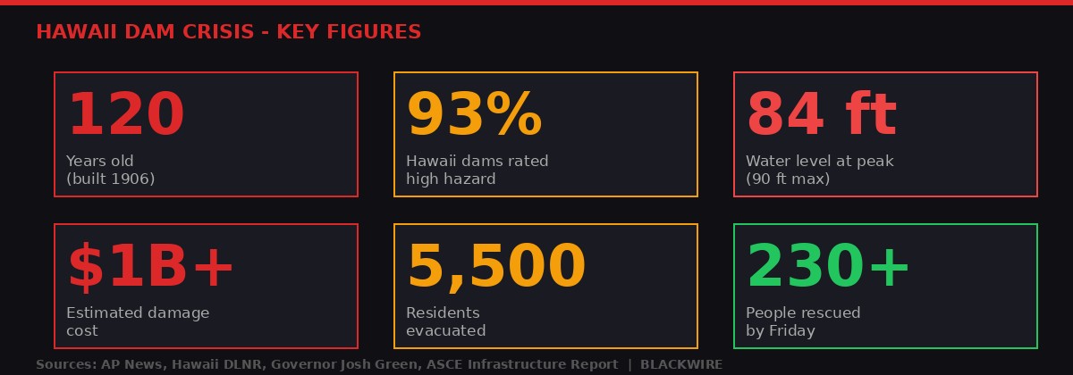
- Wahiawa dam reached 84 of 90 feet capacity - six feet from catastrophic failure
- Governor Josh Green estimates damage could exceed $1 billion statewide
- 8 to 12 inches of rain fell overnight; Kaala peak received 16 inches in 24 hours
- No deaths reported as of Friday afternoon
- 6 to 8 more inches of rain forecast over the next 48 to 72 hours
A Wall of Water Nobody Was Prepared For

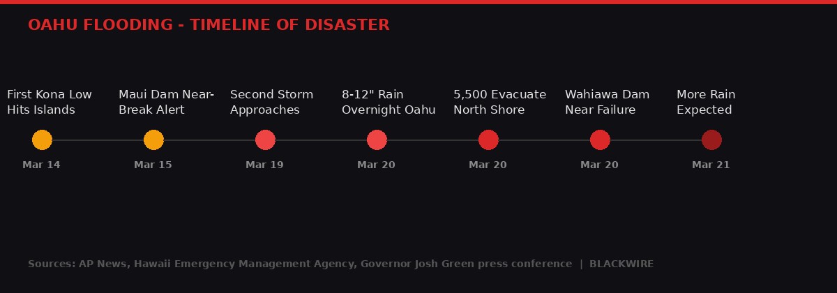
The ground was already saturated. A vicious winter storm had hammered Hawaii a week earlier - March 14 to 16 - dumping enough rain to flood farmland on Maui, close roads on three islands, and trigger a near-miss dam scare at the Kaupakalua reservoir in Haiku. State officials thought the worst was over. They were wrong.
Starting Wednesday night into Thursday, a second "Kona low" - a storm system driven by southwesterly winds saturated with Pacific moisture - swept across the archipelago. By the time it passed over Oahu's North Shore, the island had nowhere left to absorb the water.
Parts of Oahu received 8 to 12 inches of rain in a single overnight period, according to the National Weather Service. Kaala, the island's highest peak at 4,025 feet, received nearly 16 inches in 24 hours. (Source: AP News, March 20, 2026)
The results were immediate and catastrophic. The Anahulu Stream in Haleiwa - known worldwide as the entry point to the North Shore surfing circuit - burst its banks and surged through residential streets. Homes built on the floodplain were lifted from their foundations. Cars disappeared under muddy brown water. Videos posted to social media showed what looked like a river running through the center of town where a road had been hours before.
Emergency sirens activated across the North Shore just after midnight. The Honolulu Department of Emergency Management issued an order at approximately 2 a.m. Friday: "Residents in the Waialua area are strongly urged to LEAVE NOW. The remaining access road out of Waialua is at high risk of failure if rainfall continues."
By dawn, the evacuation zone covered 5,500 people across Haleiwa, Waialua, and surrounding communities.
The Wahiawa Dam: A 120-Year-Old Time Bomb

The story of the Wahiawa dam is a story of deferred decisions and structural neglect stretching back nearly two decades. It is also, as of Friday, the story of a state that came within six vertical feet of one of the worst dam failures in American history.
The Wahiawa dam was constructed in 1906 to supply irrigation water for the Waialua Agricultural Company, which later became a subsidiary of Dole Food Company. It was rebuilt after a partial collapse in 1921. The earthen structure - not concrete, not reinforced steel, but compacted earth - has been holding back the Wahiawa Reservoir ever since.
Water levels inside the reservoir normally sit around 79 feet. The dam's maximum safe capacity is 90 feet. On Thursday night into Friday morning, authorities watched the gauge climb from 79 feet to 84 feet in less than 24 hours - a six-foot rise, leaving only six feet of buffer between the water surface and catastrophic overtopping. (Source: AP News, March 20, 2026)
The state's own safety classification for Wahiawa dam is stark. According to Hawaii's Department of Land and Natural Resources, the dam has "high hazard potential" - meaning a failure "will result in probable loss of human life." That is not a bureaucratic hedge. It is a formal engineering determination. The dam's failure would send a wall of water downstream through communities that are already flooded.
"Just pray for us. We understand there's more rain coming." - Kathleen Pahinui, Waialua resident, speaking to AP News as she evacuated Friday morning
By late Friday, water levels had begun to recede at the dam. "The dam continues to operate as designed with no indications of damage," Dole said in a brief statement. But authorities cautioned that 6 to 8 more inches of rain are forecast over the weekend - and the ground has no capacity left to absorb it.
The Paper Trail: Warnings That Went Unheeded

The crisis unfolding at Wahiawa is not a surprise. It has been predicted, documented, fined, and then effectively ignored for the better part of seventeen years.
Hawaii's DLNR sent Dole Food Company its first notice of deficiency about the Wahiawa dam in 2009. Over the following decade, three more notices followed. In 2021, the state fined Dole $20,000 for failing to address dam safety deficiencies on schedule. (Source: AP News, March 20, 2026)
Twenty thousand dollars. Against a structure rated as having probable loss-of-life failure potential, holding back a reservoir that drains toward densely populated communities on Oahu's most famous stretch of coastline.
In response to the fines and notices, Dole proposed a transfer: donate the dam, reservoir, and associated ditch system to the state in exchange for the state agreeing to fund repairs and bring the structure up to current safety standards. The Hawaii legislature passed legislation in 2023 authorizing the acquisition. The state allocated $5 million to purchase the spillway and $21 million to repair and expand it.
But as of March 21, 2026 - as water crept toward the dam's maximum capacity - the legal transfer had still not been completed. A state board is scheduled to vote on the acquisition next week. (Source: AP News, March 20, 2026)
The timeline is a damning sequence: identified risk, repeated violations, token fine, years of legislative process, an incomplete transfer - and a storm that arrives before any of it could matter.
Rescue Operations and the Scale of Human Impact

By Friday afternoon, more than 230 people had been rescued across Oahu's North Shore, according to Governor Josh Green's press conference. The rescues ranged from people stranded on rooftops in Haleiwa to families trapped on second floors as ground floors filled with water. (Source: AP News, March 20, 2026)
About 10 people were transported to hospitals with hypothermia after being submerged in floodwaters for extended periods. No deaths had been reported as of Friday evening - a figure that officials attributed to the speed of the evacuation orders and the scale of the emergency response.
The National Guard mobilized helicopter units. The Honolulu Fire Department launched watercraft into flooded streets. In one of the more dramatic episodes, military helicopters airlifted 72 children and adults from a spring break youth camp at Our Lady of Kea'au retreat on Oahu's west coast. The camp sits on high ground, but floodwaters had completely cut off the access road, making the camp effectively an island. According to a spokesperson for St. Francis Healthcare System of Hawaii, which owns the property, no one at the camp was injured. (Source: AP News, March 20, 2026)
One evacuation shelter at Waialua High and Intermediate School had to be closed and its 185 occupants - plus 50 pets - bussed to a second evacuation center after floodwaters reached the shelter building itself.
Rescue operations were complicated by an unexpected problem: civilian drone operators. Honolulu spokesperson Ian Scheuring told AP that people were flying personal drones over the flooded areas to capture footage, creating airspace conflicts with rescue helicopters. Authorities issued warnings, but the problem persisted throughout the day. In a crisis where every minute of air access matters, the drone interference forced pilots to alter flight paths and timing - a detail that will likely surface in after-action reviews.
Green said his chief of staff spoke with the White House on Friday and received assurances of federal support. No formal disaster declaration had been issued as of Friday afternoon, but based on current damage estimates, officials say one is likely.
Lahaina's Ghost in the Water: Maui Joins the Emergency

The flooding is not confined to Oahu. Maui - still carrying the trauma of the August 2023 Lahaina wildfire that killed 100 people and destroyed an entire historic town - is dealing with a second emergency in the same week.
Officials on Maui issued an evacuation advisory Friday for several Lahaina neighborhoods after nearby retention basins began approaching capacity. The cruel irony is unmistakable: the same neighborhoods burned in 2023 are now at risk from water. Lahaina's surviving infrastructure was already compromised by the fire - drainage systems, retention walls, and earthworks that might otherwise have managed heavy rainfall are now untested and in some cases still under repair. (Source: AP News, March 20, 2026)
The week prior, Maui County Mayor Richard Bissen reported that some areas of Maui received more than 20 inches of rain from the first Kona low. "We're seeing flooding, landslides, sinkholes, debris and downed power lines across the county," Bissen posted on social media. About six homes on Maui and two bridges were heavily damaged or destroyed in that initial storm. (Source: AP News, March 15, 2026)
On Maui, Monday had brought its own near-miss: the Kaupakalua Dam in the Haiku community appeared to breach, triggering mass evacuations. After aerial inspection, county officials determined there was no structural damage - water had flowed over the top of the reservoir without compromising the dam's structure. But the dam, built in 1885, is scheduled to be decommissioned this summer. It was supposed to be kept empty. Instead, storm surge filled it past normal levels within hours. (Source: AP News, March 18, 2026)
PowerOutage.us tracking data showed nearly 40,000 electric customers in Hawaii without power by midday Sunday after the first storm. The second storm hit before full restoration was complete in all areas.
The Climate Driver: Kona Lows Are Getting Worse

The meteorological mechanism behind Hawaii's current crisis has a name: Kona lows. These winter storm systems form when upper-level disturbances combine with southerly or southwesterly surface winds to draw in moisture-laden air from the central Pacific. Unlike the trade wind-driven showers that normally characterize Hawaiian weather, Kona lows can stall over the islands for days, dumping rain faster than any drainage system or reservoir can handle.
Hawaii has always been vulnerable to Kona lows. But climate scientists have documented a troubling acceleration: the intensity and frequency of extreme rainfall events in Hawaii has increased significantly as human-caused global warming heats Pacific Ocean surface temperatures. More heat in the ocean means more moisture in the atmosphere. More moisture means heavier rain when systems like this arrive. (Source: AP News, citing climate research)
The state's infrastructure - roads, dams, drainage systems, coastal protections - was built for a Hawaii that no longer exists climatically. The 132 dams regulated by the state, 93% of which carry a high-hazard rating, were mostly constructed in the early twentieth century to serve the sugar industry. They were designed for rainfall patterns that predate decades of accelerating climate change. (Source: ASCE 2019 Infrastructure Report)
The 2006 Ka Loko dam collapse on Kauai remains the most deadly precedent. Seven people were killed when the dam - also an earthen structure from the plantation era - failed after heavy rainfall. The owner was later convicted of negligent homicide. The state's dam safety program was supposed to prevent a repeat. The Wahiawa situation - four notices of deficiency, a $20,000 fine, seventeen years of process - suggests the program has moved too slowly against a climate that is accelerating faster than bureaucracy can respond.
Governor Green's estimate of $1 billion in damages encompasses airports, schools, roads, residential property, and the Kula Hospital on Maui. That figure will likely grow as damage assessors gain full access to affected areas once flooding recedes.
Hawaii's Infrastructure Crisis: The Long Warning

The Wahiawa dam crisis is not an isolated failure. It is a window into a broader infrastructure emergency that Hawaii has been slow to address at every level of government.
According to the 2019 American Society of Civil Engineers infrastructure report on Hawaii, the state regulates 132 dams, the vast majority of which were built as part of plantation-era irrigation networks - the same agricultural water systems that supplied sugar cane operations across Oahu, Maui, Kauai, and the Big Island in the late nineteenth and early twentieth centuries. Of those 132 dams, 93% carry a high-hazard potential rating. That means a failure at any one of them could result in loss of life. (Source: ASCE 2019 Infrastructure Report, Hawaii)
The state's dam safety budget and inspection schedule has historically been underfunded relative to the scope of the problem. The Wahiawa situation - where Dole Food Company accumulated four deficiency notices over thirteen years before the state took meaningful action - illustrates the gap between identifying a risk and actually resolving it.
The $21 million allocated for Wahiawa dam repairs sounds significant. Against the backdrop of potential damages - a failure could destroy communities, cut critical roads, kill people - it is a relatively modest investment. More troubling is that even after the legislation passed, the transfer of ownership remained incomplete for three years. The state board vote scheduled for "next week" - March 23 or 24, 2026 - will happen with the dam still owned by a private food company and still within six feet of failure from the previous night's storm. (Source: AP News, March 20, 2026)
Beyond dams, Hawaii's road network has proven catastrophically vulnerable to the current flooding pattern. Multiple access roads on Oahu have been cut, isolating communities and complicating rescue efforts. The loss of the road into Waialua - the "last access road" referenced in the emergency alert - turned evacuation from orderly departure into a crisis. Road repair costs alone will likely account for hundreds of millions of the governor's $1 billion estimate.
The Lahaina situation adds another dimension. Post-fire infrastructure in West Maui was already operating at a reduced capacity. The decision to rebuild Lahaina without comprehensive flood-risk mitigation - something that has been debated since the 2023 fire - now looks potentially dangerous. Drainage infrastructure that might have been adequate before the fire is now untested in its current state against consecutive extreme rain events.
What Happens Next: The Weekend Forecast and Federal Response

The immediate crisis is not over. Honolulu Mayor Rick Blangiardi said Friday afternoon that 6 to 8 additional inches of rain are forecast to fall on Oahu over the next two to three days. That rain will fall on ground already saturated beyond its normal absorption capacity, on streams already running near peak, and on a dam already closer to its limits than at any point in recent memory. (Source: AP News, March 20, 2026)
The National Weather Service had placed most of the state under a flood watch as of Friday. Haleiwa and Waialua - the communities at the center of the current emergency - remained under a flash flood warning. The warning is not precautionary. It is a statement that flash flooding is occurring or is imminent based on current conditions.
Governor Green said Friday that his administration has been in direct contact with the White House, and received assurances of federal support. A formal federal disaster declaration - which would unlock FEMA funding for emergency operations, debris removal, and individual assistance - is expected to be applied for. Based on the scale of the damage, approval is likely. Hawaii's political delegation will push for rapid action: the state's economy is heavily dependent on tourism, and North Shore damage affects not just residents but the global surfing industry, which descends on Haleiwa and Pipeline every winter.
The state board vote on Wahiawa dam acquisition - scheduled for the week of March 23 - will proceed under extraordinary pressure. For seventeen years, that vote was a bureaucratic formality. Now it is a referendum on whether Hawaii can close the gap between documented risk and actual action before the next storm arrives.
"There's no question that the damage done thus far has been catastrophic." - Honolulu Mayor Rick Blangiardi, press conference, March 20, 2026
The longer question - whether Hawaii can adapt its 120-year-old agricultural water infrastructure to a climate that has fundamentally changed - has no quick answer. The legislature has funded the dam acquisition. The transfer is coming. But 93% of Hawaii's dams carry a high-hazard rating, and few have resources allocated for repair or modernization anywhere close to what the Wahiawa dam is receiving.
The next Kona low will come. It may arrive before this one fully recedes. And somewhere in the chain of 132 aging earthen structures scattered across the islands, the water level will climb again.
The Bigger Picture: America's Aging Dam Infrastructure

Hawaii is not alone. The American Society of Civil Engineers gives US dams a D+ grade in its national infrastructure report card. There are roughly 91,000 dams in the United States. The Association of State Dam Safety Officials estimates that it would cost $157 billion to repair deficient non-federal dams nationwide. Less than $1 billion per year is currently being spent on dam safety improvements across all states combined.
The pattern echoes in state after state. Oroville Dam in California - the tallest dam in the US - came within hours of catastrophic failure in February 2017 when its auxiliary spillway collapsed under high reservoir levels, forcing the evacuation of 188,000 people downstream. Federal and state regulators had been warned about spillway deficiencies for more than a decade before the near-failure. The repair bill exceeded $1.1 billion.
In New England, hundreds of mill-era dams built in the 1800s remain in private hands, many with no active inspection programs and no emergency action plans. Flooding events across Vermont, Massachusetts, and New Hampshire in recent years have brought several to near-failure, with communities downstream evacuating with little notice.
The Wahiawa situation - a privately held plantation-era earthen dam, documented deficiencies, nominal fines, slow bureaucratic transfer, extreme weather arriving before the process could complete - is not a uniquely Hawaiian failure. It is an American infrastructure story playing out under extreme weather conditions that are becoming less extreme and more routine every year.
For the families sheltering in evacuation centers across Oahu's North Shore on Friday night - listening for emergency sirens, watching weather apps, waiting to learn whether their homes still stand - the policy discussions and infrastructure grades are distant abstractions. The water is real. The sirens were real. The six-foot buffer between the dam's current water level and probable loss of human life is real.
More rain is coming this weekend. The dam is still there. The transfer is still incomplete. The vote is next week.
Get BLACKWIRE reports first.
Breaking news, investigations, and analysis - straight to your phone.
Join @blackwirenews on Telegram