A Morning Jog Exposed France's Nuclear Carrier in a War Zone
A French naval officer went for a morning run. He had Strava open. The GPS route uploaded automatically to the platform's public servers. Within hours, journalists had pinpointed the Charles de Gaulle - France's only nuclear-powered aircraft carrier - floating somewhere in the eastern Mediterranean while an active regional war raged around it.

The Charles de Gaulle carrier strike group has been in the Mediterranean since early March. One officer's fitness app gave away its position. (Illustrative)
The incident, reported by French newspaper Le Monde on Thursday and confirmed by French military officials on Friday, is an almost textbook case of how digital habits break operational security in modern warfare. The officer - whose identity has not been released - ran on or near the Charles de Gaulle on March 13. He or she used Strava, the popular fitness tracking app. The route went live on Strava's servers. Le Monde's journalists found it, cross-referenced the GPS coordinates with satellite imagery from the European Space Agency's Copernicus satellite taken the same day, and located the 42,000-ton vessel.
France is technically not a combatant in the Iran war. But France's military presence in the region is vast, active, and - after this incident - confirmed as capable of being tracked by journalists with open-source tools and a morning's patience.
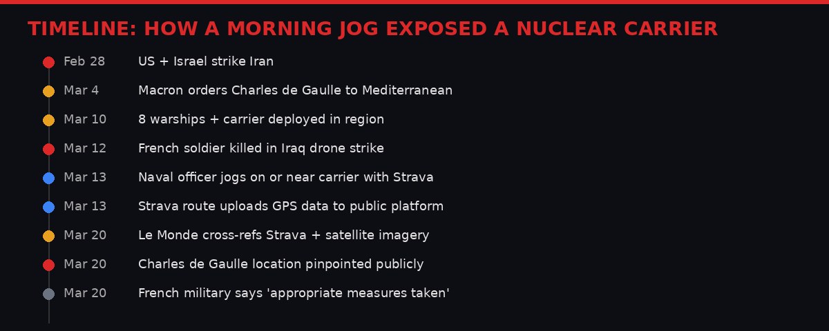
Events from the first day of the Iran war through the Strava exposure, March 2026.
What Strava Revealed - and What It Means
Strava works by recording GPS routes through a smartphone or GPS watch, then displaying them on a social map visible to other users or, in some settings, the entire internet. A user running a tight loop on the deck of a ship would generate a distinctly compact, circular or linear route - recognizable to anyone who knows what to look for on a vessel's geometry.
Le Monde reported that the officer's March 13 run enabled journalists to identify the ship's location in the Mediterranean - placing it near the coordinates 35.35 North, 30.25 East, east of Cyprus. The newspaper used satellite imagery from the Copernicus open access platform to confirm a vessel matching the Charles de Gaulle's profile at that position on the same date.
"The Strava usage reported by Le Monde does not comply with the current guidelines. Appropriate measures are being taken by the command." - Col. Guillaume Vernet, French military spokesman, March 20, 2026 (via AP)
The carrier's general deployment to the Mediterranean was publicly known - Macron announced it. Its exact position at any given moment was not. In wartime, that gap between "generally deployed" and "here is the precise grid reference" is the difference between a useful strategic ambiguity and a targeting vector.
France has been intercepting Iranian drones targeting UAE airspace. Macron confirmed French Rafale jets have conducted active interceptions since the conflict began February 28. The Charles de Gaulle itself carries 20 Rafale fighters, two Hawkeye airborne surveillance aircraft, and three helicopters - making it the most powerful single European military asset in the region. Pinning down its location, even roughly, is intelligence that hostile actors would pay for.

Open-access Copernicus satellite imagery was used to visually confirm the carrier's position after Strava provided the initial GPS coordinates.
France's Unprecedented Naval Deployment
To understand the stakes, you need to understand the scale of what France has put into the region.
When the US and Israel struck Iran on February 28, France's initial response was diplomatic caution. Macron said France was "not at war with anyone." But within days, the practical realities of the conflict forced his hand. Iran struck a British RAF base on Cyprus - an EU member state with which France has a strategic partnership. Iran-linked drones began targeting UAE airspace, where France maintains a permanent base at Abu Dhabi with pre-positioned Rafale jets and naval forces.
Macron moved fast. He redirected the Charles de Gaulle from the Baltic Sea - where it had been operating - to the Mediterranean. He announced an "unprecedented" naval deployment: eight warships, two helicopter carriers, and the carrier itself. He doubled the number of Rafale jets at Abu Dhabi from six to twelve. French frigates were dispatched to Cyprus, to the Red Sea, and to patrol lanes in the eastern Mediterranean.
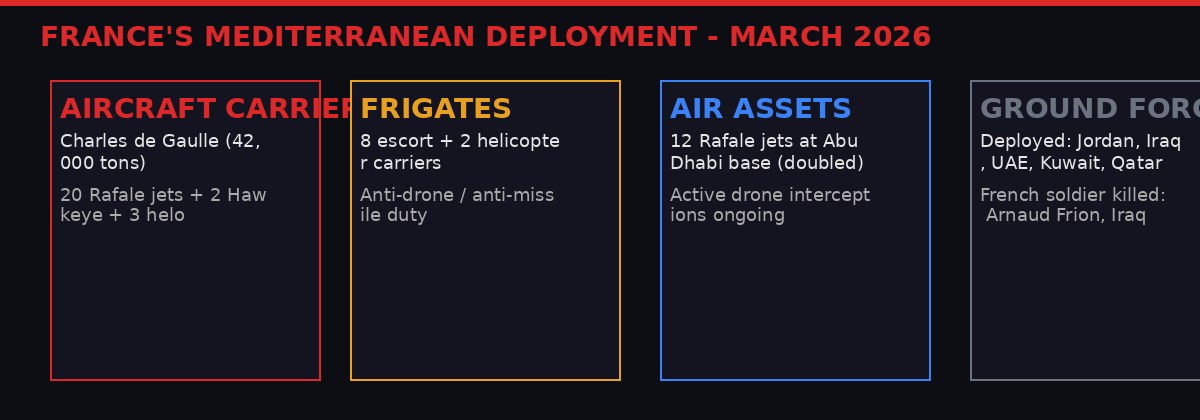
France has more than 400,000 citizens in the Middle East - more than any other European nation - and the largest European military presence in the conflict zone.
France is the European nation with the most skin in this game. More than 400,000 French citizens live in the Middle East, including over 200,000 in Israel. Macron has positioned France as a "balancing power" - militarily present but diplomatically engaged, simultaneously defending allied airspace and maintaining back-channel contact with Tehran. It is an extraordinarily delicate position, and the last thing Macron needed was his carrier's position publicly confirmed by an open-source intelligence exercise conducted by a newspaper.
"We are not at war with anyone. The presence of the Charles de Gaulle in the Mediterranean demonstrates France's strength: a balancing power, a force for peace." - President Emmanuel Macron, during his visit to the Charles de Gaulle, March 2026 (via AP)
A Recurring OPSEC Crisis That Nobody Fixes
The France-Strava incident is not new. It is the latest chapter in a long and embarrassing history of fitness apps destroying military operational security - a problem the military world has been aware of for almost a decade and has largely failed to solve.
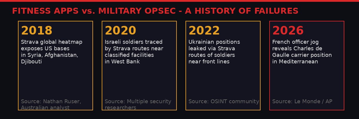
The Charles de Gaulle incident follows a documented pattern of military secrets exposed by commercial fitness apps since 2018.
In January 2018, Nathan Ruser, an analyst with the Australian Strategic Policy Institute, noticed something odd in Strava's global fitness heatmap - a visualization of all aggregated workout routes on the platform. In remote areas of Syria, Afghanistan, and Djibouti, bright lines of activity cut through the darkness. These were US military personnel running laps and routes around classified forward operating bases. The heatmap had exposed the locations, perimeters, and internal layouts of installations that weren't supposed to exist publicly. The US military scrambled to issue guidance. Individual commands began banning fitness trackers in certain zones.
The guidance, it turns out, was inconsistently applied and inconsistently enforced. In 2020, Israeli security researchers found Strava routes attributable to soldiers training near classified facilities in the West Bank. In 2022, OSINT analysts tracking the Ukraine conflict identified military personnel positions partly through fitness data. Each incident generated a round of internal memos, updated guidelines, and promises to do better. Then the next incident happened.
The Charles de Gaulle breach follows the same pattern. The French navy has protocols. Col. Vernet confirmed that sailors are "regularly made aware of the security risks associated with connected devices." Different levels of restriction on connected devices are applied based on "the level of threat." Apparently, the March 13 threat level did not trigger the restriction that would have kept this officer off Strava.
This is the institutional failure at the heart of every such incident: the policy exists but compliance is treated as an individual responsibility rather than a structural enforcement problem. An officer who wants to track a morning workout will track it unless the technology is physically unavailable or automatically blocked. Awareness campaigns and memos do not compete effectively with the ingrained personal habit of using a fitness app.
What Iran - or Anyone Else - Could Have Done with This Information
France has been careful to characterize its military presence as defensive. But "defensive" is a legal and political category, not a strategic one. The Charles de Gaulle's Rafale jets have been intercepting Iranian drones over UAE airspace. That makes the carrier - in the operational logic of the IRGC - a legitimate target or at minimum a priority intelligence asset.
Iran has demonstrated sustained capability for long-range drone strikes throughout this conflict. Saudi Arabia reported intercepting 20 Iranian drones in just a few hours on Friday night - in the eastern region of the country, near major oil installations. Iran has struck British, American, and allied facilities across Iraq, Kuwait, Bahrain, and Cyprus. It has threatened to expand attacks to "parks, recreational areas, and tourist destinations worldwide," according to Gen. Abolfazl Shekarchi, Iran's top military spokesperson, on Friday. (AP News, March 20, 2026)

The carrier's precise location exposed by commercial GPS data represents exactly the kind of open-source intelligence advantage that state and non-state actors actively seek.
The Charles de Gaulle was not near the direct combat zone. It was positioned in the eastern Mediterranean, likely somewhere between Cyprus and Lebanon, providing air cover and standoff capability. But knowing its approximate position removes ambiguity for anyone trying to calculate its reach - or its vulnerability.
Drone threats do not require precision targeting to be effective. A known general area is sufficient to concentrate drone activity and test air defense responses. Intelligence about carrier group positioning also informs decisions about what corridor to attack through, where French frigates are screening, and where coverage gaps might exist.
The French military's terse statement - "appropriate measures are being taken" - tells you almost nothing about whether this information was already circulating in adversary intelligence networks before Le Monde published it, or whether the damage was limited to the public exposure alone. Those are very different situations.
Macron's Diplomatic Tightrope Gets Harder
There is a second, less kinetic dimension to this story: the embarrassment factor for Macron's carefully constructed diplomatic positioning.
France has bet on being the European interlocutor for the post-war settlement. Macron has maintained communication channels with Tehran even as French jets intercept Iranian drones. He has publicly criticized the US-Israel strikes as outside "international law" while simultaneously defending French partners in the Gulf. He has refused to join the US-led coalition formally while deploying more military assets than any other European country.
This requires Iran to see France as a credible non-combatant - at least diplomatically. An incident that confirms France's nuclear carrier is actively operating in the Mediterranean, close enough to the conflict zone to be relevant, complicates that positioning. It confirms what Tehran already suspects: that France's "defensive" role is, in practice, integrated into the same system of force projection that is grinding down Iranian military capability.
"We stand by the side of our allies and our friends. There have been some interceptions that have continued in recent days. We do so within the framework of our partnerships." - President Macron, during carrier visit, March 2026 (via AP)
Macron also used the carrier incident - even before the Strava embarrassment broke - to announce France's next nuclear aircraft carrier. The France Libre (Free France) will displace 80,000 tons, carry 30 Rafales and 2,000 sailors, and enter service in 2038. The announcement was framed as a demonstration of French long-term commitment to naval power. The Strava incident the same week was not the announcement Macron wanted to follow it.
The Open-Source Intelligence Revolution That Militaries Are Losing To
Le Monde's investigation was not high-tech. It required a Strava account, a subscription to Copernicus satellite data (which is free and open to the public), and the journalistic instinct to connect two public data sources. The entire investigation could have been conducted by a teenager with a laptop.
This is the central challenge that militaries are struggling to absorb: the tools of open-source intelligence have democratized to the point where state-level surveillance capabilities are available to anyone with an internet connection and the patience to use them. Satellite imagery that was classified military capability 20 years ago is now free. GPS tracking that would have required a covert operation to plant is now voluntarily published by the person you are tracking. Social media posts geotag locations automatically. Shipping tracking sites show vessel positions in real time. Flight tracking apps follow military aircraft.
The Strava-Charles de Gaulle connection is a perfect illustration of how these data streams converge. A GPS trace from a consumer fitness app + a satellite image from a European Space Agency open-access platform + the knowledge that a carrier was deployed to the Mediterranean = the precise location of a nuclear-powered warship in a war zone. No espionage required. No hacking. No classified intercepts. Just open-source data, combined intelligently.
Bellingcat built its global reputation on exactly this kind of work - identifying the BUK missile launcher that shot down MH17, tracking Russian military equipment in Ukraine, locating covert military operations through publicly available data. The same methodology that Bellingcat used to hold governments accountable for war crimes can be used by those same governments' adversaries to locate their assets.
There is no technological fix that is both effective and proportionate. Banning smartphones on military vessels entirely is logistically difficult and extremely unpopular with sailors who spend months at sea. Requiring GPS spoofing or blocking on personal devices creates its own complications. The only reliable solution is cultural - making every service member understand that their personal devices are intelligence liabilities, not just personal property - and culture change in large institutions is slow, uneven, and often fails under the pressure of ingrained habit.

The methodology that exposed the Charles de Gaulle required only public data sources - no hacking, no classified access, no espionage tradecraft.
What Happens Now
The French military's "appropriate measures" likely means the officer has been disciplined, phone policies on the vessel have been tightened, and the incident has been added to the training curriculum for the next OPSEC awareness cycle. The same things that happened after every previous Strava incident.
What will not happen: a fundamental restructuring of how military institutions manage the digital lives of their personnel. That would require acknowledging that the problem is structural, not individual - and that would mean acknowledging that "regular awareness briefings" are not sufficient. Institutions rarely voluntarily reach that conclusion until the consequences of the structural failure become catastrophic enough to force it.
For France specifically, the immediate operational concern is whether the Charles de Gaulle has been repositioned since the incident became public. A carrier group's advantage lies partly in strategic ambiguity - if an adversary cannot be certain where the carrier is, they cannot plan around it. Le Monde's publication on Thursday removed that ambiguity for the March 13 position. The ship moves continuously, so the precise coordinates are already stale. But the methodology is now demonstrated, and any actor with a Strava subscription and satellite access can attempt to repeat it.
The Iranian military is watching this conflict through every intelligence lens available to it. The IRGC runs sophisticated intelligence operations - its Quds Force tracked and targeted French assets in Lebanon and Syria for years. The question of whether Iranian intelligence independently identified the carrier's location through Strava before Le Monde published is not answerable from open sources. But it is the question the French DGSE is asking.
Meanwhile, the war continues. Saudi Arabia intercepted 20 Iranian drones Friday night near its eastern oil fields. Iran threatened global tourist sites. Trump simultaneously posted about "winding down" the war and announced 2,500 additional Marines heading to the region. Oil sits at $108 a barrel. And somewhere in the eastern Mediterranean, the Charles de Gaulle is still out there - slightly less hidden than it was a week ago.
Sources: AP News (March 20, 2026), Le Monde (March 20, 2026), French Ministry of Defense statement via AP, Copernicus satellite data, Strava platform data.
Get BLACKWIRE reports first.
Breaking news, investigations, and analysis - straight to your phone.
Join @blackwirenews on Telegram